Back نيغاتا Arabic Niiqata Azerbaijani نیقاتا AZB Ниигата (ҡала) Bashkir Kota Niigata BAN Ніігата (горад) Byelorussian Ниигата (град) Bulgarian নিইগাতা Bengali/Bangla Niigata Breton Niigata Catalan
You can help expand this article with text translated from the corresponding article in Japanese. (February 2022) Click [show] for important translation instructions.
|
Niigata
新潟市 | |||||||||
|---|---|---|---|---|---|---|---|---|---|
| Niigata City | |||||||||
| |||||||||
 | |||||||||
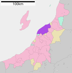
 Location of Niigata in Niigata Prefecture | |||||||||
| Coordinates: 37°54′58″N 139°2′11″E / 37.91611°N 139.03639°E | |||||||||
| Country | Japan | ||||||||
| Region | Chūbu (Kōshin'etsu) (Hokuriku) | ||||||||
| Prefecture | Niigata | ||||||||
| City Status | April 1, 1889[citation needed] city incorporation ) | ||||||||
| Government | |||||||||
| • Mayor | Yaichi Nakahara (from November, 2018) | ||||||||
| Area | |||||||||
| • Designated city | 726.45 km2 (280.48 sq mi) | ||||||||
| Population (July 1, 2019) | |||||||||
| • Designated city | 797,591 | ||||||||
| • Density | 1,100/km2 (2,800/sq mi) | ||||||||
| • Metro [1] (2015) | 1,060,013 (17th) | ||||||||
| Time zone | UTC+9 (Japan Standard Time) | ||||||||
| Phone number | 025-243-4894 | ||||||||
| Address | 1-602-1 Gakkōchō-dōri, Chūō-ku, Niigata-shi, Niigata-ken 951-8550 | ||||||||
| Climate | Cfa | ||||||||
| Website | city.niigata.lg.jp | ||||||||
| Symbols | |||||||||
| Bird | Swan | ||||||||
| Flower | Tulip | ||||||||
| Tree | Willow | ||||||||
| Niigata | |||||
|---|---|---|---|---|---|
"Niigata" in kanji | |||||
| Japanese name | |||||
| Kanji | 新潟 | ||||
| |||||
Niigata (新潟市, Niigata-shi, [niːɡata]) is a city located in the northern part of Niigata Prefecture. It is the capital and the most populous city of Niigata Prefecture, and one of the cities designated by government ordinance of Japan, located in the Chūbu region of Japan. It is the most populous city on the west coast of Honshu, and the second populous city in Chūbu region after Nagoya. It faces the Sea of Japan and Sado Island. As of 1 September 2022[update], the city had an estimated population of 779,049, and a population density of 1,072 persons per km2. The total area is 726.45 square kilometres (280.48 sq mi). Greater Niigata, the Niigata Metropolitan Employment Area, has a GDP of US$43.3 billion as of 2010.[2][3]
It is the only government-designated city on the west coast of Honshu. It has the greatest habitable area of cities in Japan.
- ^ "UEA Code Tables". Center for Spatial Information Science, University of Tokyo. Retrieved January 26, 2019.
- ^ Yoshitsugu Kanemoto. "Metropolitan Employment Area (MEA) Data". Center for Spatial Information Science, The University of Tokyo. Archived from the original on 2018-06-15. Retrieved 2016-09-29.
- ^ Conversion rates - Exchange rates - OECD Data
© MMXXIII Rich X Search. We shall prevail. All rights reserved. Rich X Search


